Saginaw Bay is a relatively shallow embayment located in southwest Lake Huron, in between Michigan’s “mitten” and “thumb.” Although the bay has been previously known for being degraded due to human activity, today, it is a popular spot for all watersports, and it is especially popular with Great Lakes anglers.
In recent years, Saginaw Bay has seen a significant increase in Walleye catch rates, and continues to be one of the best spots to catch ‘the star of the Great Lakes.’ Saginaw Bay fishing doesn’t necessarily cease after the warm weather. It is also heralded as one of the best places to ice fish in the country. This previous winter (2024-25), GLOS kicked off a project to try and fill the ice thickness data gap around the Great Lakes. With the help from regional ice fishers, this will help improve ice modeling efforts around the Great Lakes (If you are interested in helping contribute ice thickness measurements this coming winter, or if you have historical records, please reach out to Shelby).
The user-submitted ice observations are not the only eyes on this Lake Huron bay. NOAA is the primary caretaker of the real-time observing assets in Saginaw Bay. The agency is responsible for maintaining the buoy and meteorological stations that steadfastly collect information on the water and weather.
Buoys
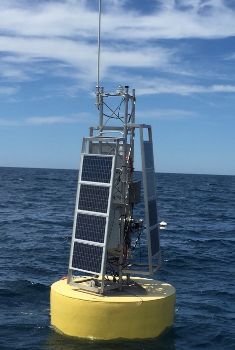
Saginaw Bay Buoy 45163 – NOAA-GLERL
Deployed since 2010 by NOAA’s Great Lakes Environmental Research Lab (GLERL), the long-standing Saginaw Bay Buoy measures 2 meter winds, waves, water quality, water temperature, and water currents. It is deployed in approximately 44 feet of water and reports data every 20 minutes. In 2024, over 600 people viewed the platform page over 2,600 times (on Seagull). It has provided valuable safety and water condition information, as well as providing long term trends in water quality for this very important recreational fishery. The Saginaw Bay can be a difficult place to forecast the winds and waves, a task that NOAA’s National Weather Service takes on daily. These observation datasets allow NWS Forecasters to verify marine forecasts and short-fused warnings.
Meteorological stations
Gravelly Shoal Light
NOAA-NWS
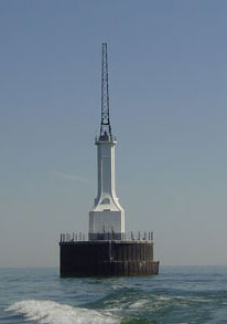
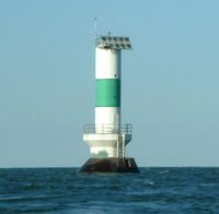
The Gravelly Shoal Light and Saginaw Bay Light #1 weather stations are owned and managed by the Central Region of NOAA’s NWS and has been operated since 2005 and 2008, respectively. The weather stations are located on the structures and provide wind, atmospheric pressure, and air temperature measurements. The Gravelly Shoal Light helps mark the entrance to Saginaw Bay from the open waters of Lake Huron, whereas the Saginaw Bay Light #1 offers a focused look at how weather conditions are evolving within the bay itself. Boating traffic on Saginaw Bay varies from smaller recreational boats to large commercial freighters; therefore, these observations are critical for safe navigation and decision making, as they provide a near real-time look at the wind, atmospheric pressure, and air temperature. Saginaw Bay can be a difficult place to forecast the winds and waves, a task that NOAA’s National Weather Service takes on daily. These observation datasets allow NWS Forecasters to verify marine forecasts and short-fused warnings, in addition to NOAA weather, waves, and circulation forecasting; showing just how important this information is for safety of navigation for Great Lakes commercial freighters and recreational boaters.
Saginaw Bay Light #1
NOAA-NWS
Future Assets
NOAA GLERL has deployed two additional buoys in Saginaw Bay as part of their effort to better understand Great Lakes harmful algal blooms and carbon dynamics.
Additionally, Saginaw Valley State University also has plans to build out a Saginaw Bay research station that will add capacity to the area.