In 2017 and again in 2019, when Philip Chatterton saw lake levels rising around him and flood waters endangering his own home and community, he needed real-time information, and fast.
“When they said that the water was 75.3 meters above sea level, it didn’t mean a lot,” said Chatterton, a web developer and database administrator. “I wanted to know, Is the rail yard flooded? I wanted to know if I could get to the dock, on my boat or not. I wanted to know if I could get to my house.”
Both times, the floods surrounded his home with two feet of water, covered the roadway with another foot, blocked emergency response vehicles, and nearly swept away the community’s century-old historic yacht club. And these weren’t isolated challenges. Throughout the Great Lakes in recent years, coastal communities have experienced similar flooding, along with erosion, and other serious consequences of record lake levels.
“We had no idea how fast the water was rising. We had no idea where it was going to go because water goes where it wants to go,” he said.
But Chatterton had an idea. “I just felt all along that I wanted a series of little markers, little points along the way that could tell me the progression of the water in a meaningful way.”
And so, in 2019 after the flood water subsided, and over the next two years, Chatterton designed his first Flood Dog—a simple, open-source device that measures ground, surface, and lake water levels in real-time and sends data every 15-30 minutes.
And, early this year, GLOS funded Chatterton’s project through a Smart Great Lakes mini-grant, allowing him to build 42 devices, distribute them throughout the Toronto Islands, and build an API to start sending the data to Seagull.
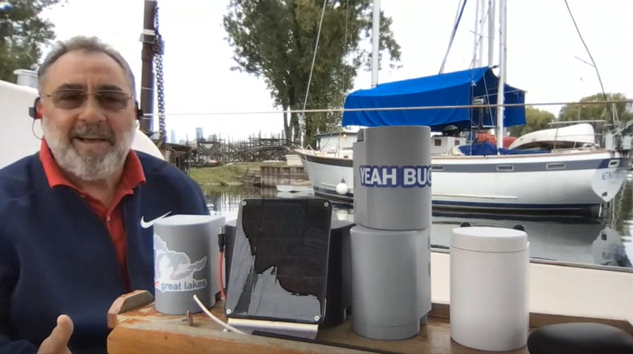
Housed in plastic, 3D printed cases about the size of a coffee mug, a Flood Dog contains a microprocessor with a cellular transmitter and off-the-shelf and ‘open source’ printed circuit boards, all powered by a solar charged lithium polymer battery. The sensors measure water levels using several methods: soil moisture and capacitance for ground water levels, water pressure to measure lake levels, and resistive sensors to detect surface water. The devices are designed to run 24/7 for three years, Chatterton expects.
“This is a new kind of project for GLOS, very different from supporting a buoy or other larger kind of scientific equipment,” said Becky Pearson, GLOS’ chief operations officer. “This is a lightweight, reproducible device that could provide critical information to coastal or flood-prone communities all over the region.”
Though designed and built by Chatterton, he says that there was a large network of people behind the project. Chatterton worked with board manufacturers and a 3D printing partner, who is currently printing Flood Dog cases 24 hours a day. And there is online open-source community, who taught him much of what he needed to code, order, solder, and 3D print the devices.
And because every component is open-source, with everything from software to 3D printing models available for free online, these devices can be easily replicated—ordered and printed within a matter of hours.
“All they have to do is to download all the parts and pieces, and they can make one and start monitoring the world around them in real time,” Chatterton says.
Once the devices are in place, Chatterton will make data available through his website, and as Seagull capacity grows, the GLOS team will evaluate how to display the data so that others can view it alongside information from the rest of the observing network.