


Photos by Hans VanSumeren and Northwestern Michigan College.
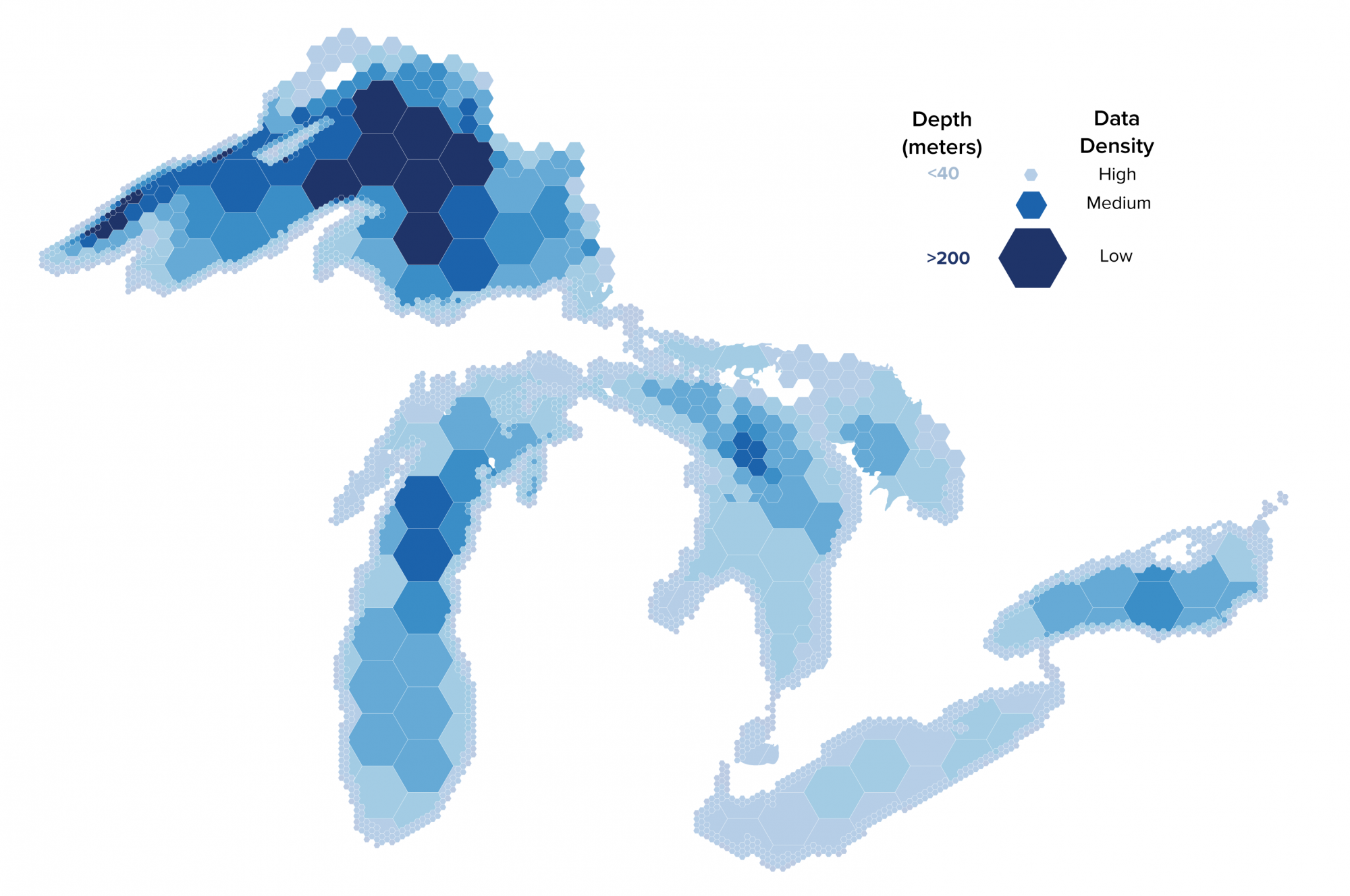
Map the Great Lakes
The objective of the Lakebed 2030 conference is to bring together science and research, policy, government, and industry professionals to:
- Focus on high-resolution mapping and bathymetry data in the Great lakes.
- Work towards a strategy to catalog new and existing lakebed information for shared use.
- Share the latest technology advancements with the Great Lakes community.
Sponsors
Platinum
Gold


Silver


Bronze


Program Support

2024 Presentation Slides
Matthew Child | International Joint Commission
Development of a
Great Lakes Science Plan:
Alignment with Lakebed 2030

Meredith Westington | NOAA
Bi-National Bathymetry Coverage and Gap Analysis Pilot

Tim Kearns | GLOS
Conquering Data in the Great Lakes through a Joint Venture

Christy Fandel | NOAA
Coast Survey’s Hydrographic Surveying Program: Planning, Managing, and Qualifying Hydrographic Survey Data Acquisition in the Great Lakes

Dave Bernstein | NV5
Adding to the Map: Large-scale Charting Efforts of Lake Michigan Contribute to Lakebed 2030 Initiatives

Matt Holland | NORBIT/SailDrone
Shallow and Extended Range Lakebed Mapping with Long-endurance USVs

Kyle Goodrich | TCarta
Great Lakes Satellite Derived Bathymetry: Successes, Failures, and New Approaches

Lara O’Brien | NOAA
Looking Below the Surface: An Update on Benthic Habitat Mapping in the Great Lakes

Phillipe Wernette | MTU GLRC
Benthic Habitat Mapping: Integrating AUVs and ROVs with Photogrammetry and Machine Learning

Charles Menza | NOAA
Modernizing Great Lakes Benthic Mapping: Updates on a Collaborative Workflow

Millicent Pitts | Oceans Exchange
Why Lakebed 2030 Matters

Dana Gallent | Canadian Hydrographic Service
Status of Mapping/Charting on the Canadian Side of the Great Lakes and Opportunities to Increase Contributions from Other Interested Organizations along with New Technologies

Andy Armstrong | NOAA
NOAA’s New Center of Excellence for Operational Ocean and Great Lakes Mapping

Travis White | MTU GLRC
Lake Superior Mapping and Archaeological Exploration Using Uncrewed Technology and High-Performance Multibeam

Josephine Johnson | US Fish & Wildlife Service
Between Two Lakes: Habitat Mapping in the Niagara River

Helen Stewart | Fugro
A Community-led Plan to Explore the Underwater Cultural Heritage of Flathead Lake, Montana

Caitlin Zant | Wisconsin Shipwreck Coast National Marine Sanctuary
Deep Crater Structures in the Milwaukee Basin

Tim Kearns | GLOS
Where in the World Is Data?

2022 Recordings
Senator Gary Peters | Welcome to Lakebed 2030
Hans VanSumeren | Wrapup
Denis Hains | Hydrospatial Data for Better Understanding of the Great Lakes!
Charles Menza | Characterizing Lakebed Habitats Using Remotely-sensed Data and Predictive Modeling
Tim Kearns | Lakebed 2030 Next Steps to Realizing the Goal
Linden Brinks | Lakebed 2030 Visualizing Progress
Nathaniel Penrod | Modeling the Risk of Dreissenid Mussel Colonization
Nick Azzopardi | Successes and Challenges from Two Years of Great Lakes Mapping
Michelle Levano and Sarah Thompson | Acquisition Methods for Charting of Approaches to Cleveland
Matt Holland and Mike Mutschler | High Performance and Low Carbon Mapping for the Great Lakes
John Bright | NOAA Great Lakes Research Vessel Mapping Updates for 2022
Jessica Nation | NCEI Bathymetry Team: Data Contribution, Sharing, Accessibility, and Archive
Evan Martzial | Absolute Ocean, A Cloud Based Geospatial Data Management Platform
Dave Bernstein and Russ Green | Large-scale Charting of Lake Michigan and the WSCNMS
Christine Delbridge | Canadian Hydrographic Service’s Approach to Bathymetric Gap Analysis
Evans, VanSumeren, Kearns | Mapping the Great Lakes: Gaps, Barriers, and Opportunities
Ayman Mabrouk | Ground Truthing for Lakebed Maps in the Great Lakes
Scott Spurgeon | Creating a Near-Seamless Digital Elevation Model of Lake Ontario
Brandon Krumwiede | Update on Great Lakes Benthic Habitat Mapping
Robin Mattheus | Monitoring Nearshore Morphodynamics at Illinois Beach State Park, Lake Michigan
Kitch Kennedy | Multi sensor, Low impact Data Collection in Support of Lakebed 2030