By Tom Hollenhorst, EPA Office of Research and Development, Toxicology and Ecology Division
This is part of the Smart Project Series—stories published by Smart Great Lakes Initiative (SGLi) partners that explore current or future projects that sum up what it means to be “smart,” as established in the Common Strategy for Smart Great Lakes.
The Common Strategy is the key document of the SGLi and will be available for public comment Aug. 23-Sept. 24. Learn more and review the document.
Who is monitoring what in your part of the Great Lakes in 2021, 2022 and beyond?
Each year scientists from various agencies, tribal governments, and institutions involved with different areas of interest within the Great Lakes informally share information about planned monitoring and sampling. This could be part of each lake’s Cooperative Science Monitoring Initiative (CSMI), monitoring in Areas of Concern (AOCs), coastal areas and other assessment areas (e.g. National Coastal Condition Assessment, state water quality reporting, etc.).
This information sharing effort occurs in many forms across the Great Lakes. It occurs informally among colleagues at conferences and via planning meetings among field crews and principle investigators, more formally among funding agencies, but often with little coordination across agencies, tribal governments, and institutions. The Smart Great Lakes Initiative could help with this coordination, providing a data platform for sharing planning information.
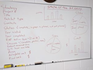
The Smart Great Lakes Initiative could help facilitate and leverage this informal information sharing using smart technologies to capture and archive the information and then share it back out again via interactive maps and databases. For identified specific geographies (Whole Lakes, connecting channels, AOC’s, etc.), we would ask via an online form and other surveys, questions like these:
- If you can think of someone that should be on this list, please add them here ___.
- Who’s doing the work (e.g., program and people)?
- What will you be doing (e.g., parameters collected)?
- What equipment will you be using (e.g., ships, boats, canoes, samplers, etc.)?
- Where are your sampling locations (e.g., descriptions or coordinates)?
- When will you be doing the work (e.g., target period and include frequency if more than once)?
- Why are you doing this sampling (e.g., sampling/project goals/objectives, regulatory requirements, etc.)?
- Where does your data get stored?
This information will then be served back to the participating entities for their planning and collaboration efforts. Success will be marked by awareness of other projects overlapping by location/time/data set, developing an audience for a data set, or spurring on collaborations around specific sites or research/management questions.
The Science in the Great Lakes Mapper (SiGL) documents monitoring data the various agencies are collecting and is one example of how this shared info could be mapped and shared. The system is set up to allow relatively easy entry of metadata describing monitoring efforts. If the agencies were willing to enter metadata corresponding to their efforts, it would provide a tool that could be used to identify gaps in current monitoring efforts and show how efforts could be coordinated across agencies.