Smart Great Lakes projects continue to progress across the region. Below you will find a few highlighted projects submitted by SGLi partners. These are just a few examples of projects that advance SGLi goals as part of our Common Strategy.
SGLi Partner Project Updates
(2.18.2025)
Submitted by John Lenters, University of Michigan Biological Station
In support of the Smart Great Lakes Initiative, partners with the Great Lakes Evaporation Network (GLEN) have been working over the past two years to implement GLOS-funded infrastructure upgrades at the two longest-running GLEN sites on Lake Superior (Stannard Rock and Granite Island). This has included data management upgrades such as the integration of Great Lakes evaporation and related flux data into the AmeriFlux network at sites US-GL1 and US-GL2, as well as the publication of a data paper describing the first 15 years of eddy covariance data from Stannard Rock. Recent instrumentation upgrades have included the implementation of a LI-COR “SmartFlux” device at Granite Island, allowing for access to fully-processed half-hourly flux data in real time (a first in the history of the GLEN network). A radio link and remote weather station at Stannard Rock has allowed for real-time data transmission to NOAA’s National Weather Service, and a new SmartFlux system will also be installed at Stannard Rock this coming year. Partners on the recent GLEN upgrades include Chris Spence and Newell Hedstrom (Environment and Climate Change Canada), Erin Nicholls (University of Calgary), John Lenters (University of Michigan Biological Station), and Peter Blanken (University of Colorado Boulder).
Photos by John Lenters


Submitted by Sasindu Gunawardana, Trent University
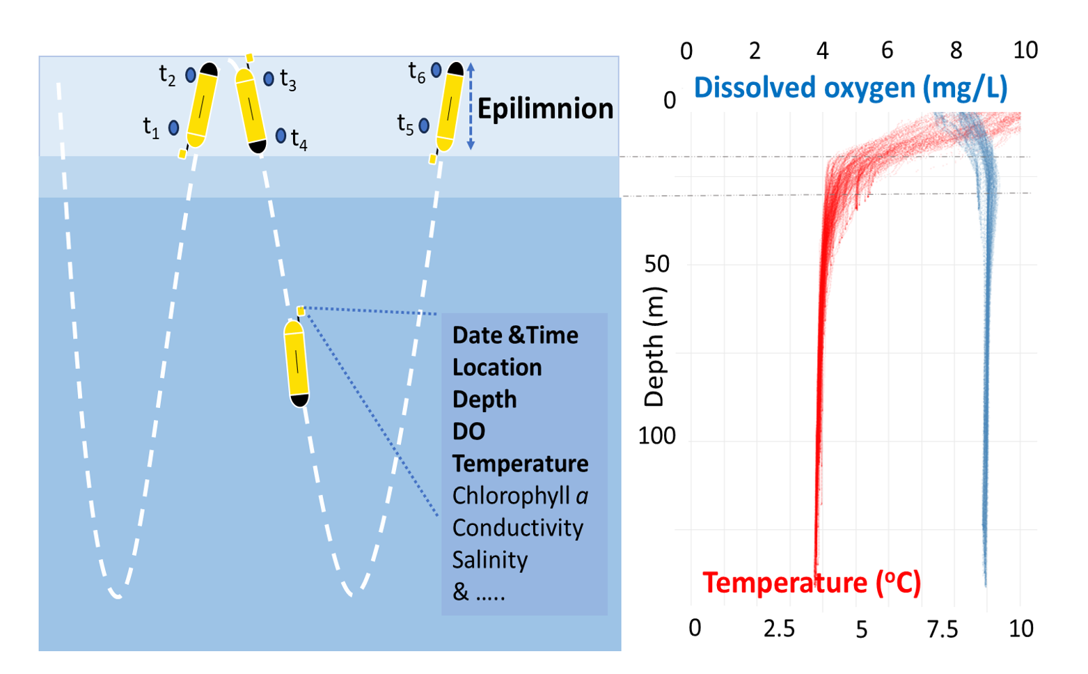
I’m Sasindu Gunawardana, a PhD candidate from Trent University. In my Ph.D. research, I leverage data from Autonomous Underwater Vehicles (AUVs) / Gliders, supported by the GLOS, to study biogeochemical changes, especially carbon metabolism across the Great Lakes. Using multi-year glider missions, I estimate carbon dynamics in Lake Superior and investigate biogeochemical shifts during a fall turnover and hypoxic event in Lake Erie. Additionally, I compare glider-derived carbon metabolic estimates with static buoy-based measurements to assess methodological uncertainties and improve our understanding of carbon cycling in the Great Lakes.
Check out my findings on carbon metabolism in Lake Superior’s upper mixed column: http://dx.doi.org/10.1029/2024GL110601
Gunawardana, P. V. S. L., Pearce, N. J. T., Austin, J. A., Hollenhorst, T., Hoffman, J. C., & Xenopoulos, M. A. (2025). The Metabolic Balance of Lake Superior’s Mixed Layer. Geophysical Research Letters. 52, e2024GL110601
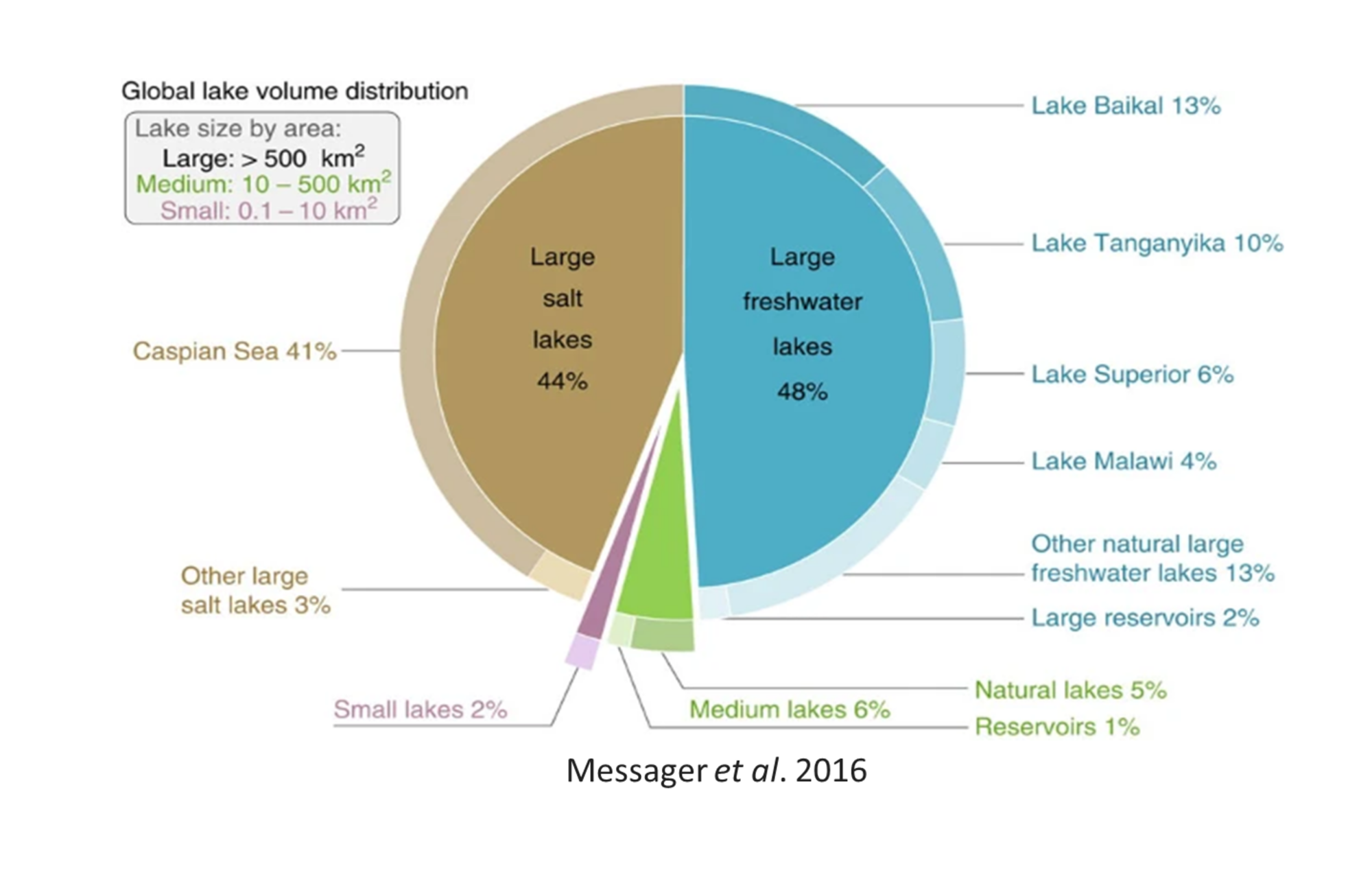
Image 1 from Messager, M., Lehner, B., Grill, G. et al. Estimating the volume and age of water stored in global lakes using a geo-statistical approach. Nat Commun 7, 13603 (2016)
Image 2 by Sasindu Gunawardana
Submitted by Michael Twiss, Algoma University
Our project: The REASON (River Environment and Sensor Observation Network) Project: Understanding Ecosystem Change on the St. Lawrence River-Kaniatarowanenneh to Support Community Strategies for Well-Being.
Outputs: Training Mohawk Council of Akwesasne (MCA) technicians in use of advanced water quality monitoring instrumentation; establishment of a permanent water quality sampling station in the Kana:takon (St. Regis) Water Treatment Facility on the south shore of the St. Lawrence River.
Outcomes: Instrumentation was on loan from RAEON and had to be returned at the end of the project so Twiss has provided an indefinite loan of a Turner-Design C6 instrument to MCA for use at Kana:takon. Our partners at the River Institute in Cornwall assist with the operation of this water quality monitoring station. Data are used by MCA to understand seasonal changes in quality of the water that is used to serve their community’s drinking water needs.
Johanna Dipple, McGill University
Digital Tools for Water Governance:Repositioning Information Communication Technology in a Data-to-Wisdom Framework in the Great Lakes Basin
Water governance in the Laurentian Great Lakes Basin (GLB) is a model for successful transboundary governance and public engagement with environmental issues. Recent technological advances have facilitated the collection, storage, and processing of data, including a shift towards the provision of open and accessible data for public use. Information Communication Technology (ICT) tools have emerged as a mechanism to communicate scientific data to a non-specialized audience, including dashboards, interactive web maps, virtual simulations, and data viewers. While many platforms exist, there is a lack of comprehensive reviews of these platforms, and limited emphasis on data outcomes and accessibility for non-scientists. The current focus on data provision risks these platforms becoming ends in themselves, instead of encouraging data-driven decision-making.
This thesis examines the ICT tools within the GLB. Specifically, this thesis seeks to assess (1) What delivery of freshwater data is provided through online ICT tools in the GLB?, and (2) How do practitioners perceive the role of ICT tools in driving platform user decision-making?
This research applies a knowledge sciences framework – the Data-Information-Knowledge-Wisdom (DIKW) Hierarchy – to explore the process of knowledge creation and mobilization through ICT. Chapter 1 introduces the methodologies used in this thesis, namely systematic scoping reviews and key informant interviews. Chapter 2 provides the historical and contemporary context of water governance in the GLB, the framing of ICT tools and their relevance to open data accessibility, and the conceptual framework that guides the thesis. Chapter 3 is a systematic scoping review of ICT platforms relevant to GLB water quality and quantity. Chapter 4 is a study of open data platform practitioners, utilizing semi-structured key informant interviews to explore outcomes and challenges of these tools in practice. The results of this thesis include an adapted DIKW framework to aid in understanding Data mobilization in this context, and indicate that ICT tools are in a state of transition. Recommendations argue for a repositioning of the value of these platforms as supplements – rather than substitutes – to in-person initiatives, and suggest specific measures for shifting the focus of ICT platform usage from data provision to informing platform user decision-making.
Emilie DeRochie, River Institute
River Strategy description
The St. Lawrence River Strategy (River Strategy) was founded in partnership between the St. Lawrence River Institute (River Institute) and the Mohawk Council of Akwesasne – Environment Program to facilitate connection for a more beautiful and healthy St. Lawrence River for all. To achieve increased communication and collaboration, the River Strategy cultivates a community agreed-upon, value-informed space for people and organizations from across the region to gather, connect, share knowledge and information, and identify opportunities to work together towards shared goals for the river, guided by the Haudenosaunee Two-Row Wampum Approach.
Although still in its early stages, the River Strategy has seen great success in gathering individuals and organizations from across the St. Lawrence River watershed to discuss challenges and priorities for the river, as well as launch several subcommittees and working groups as they work towards shared goals.
Learn more about the River Strategy: https://stlawrenceriverstrategy.com/
Photos by Stephany Hildebrand and provided by Emilie DeRochie


Max Herzog, Cleveland Water Alliance
Water Accelerator Testbeds: A robust, IoT-enabled network of monitoring assets which, together with CWA’s technical support, insurance protection, and entrepreneurial mentorship, enables rapid, derisked demonstration of innovative water technologies. The testbeds include a range of environmental conditions and industry settings that allow innovators of any size, from start-ups to multinational corporations, to accelerate commercialization of the next generation of water solutions.
Smart Lake Erie Watershed (SLEW): CWA has outfitted the Lake Erie Watershed with a state-of-the-art telecommunications infrastructure and hundreds of IoT sensors, making it the largest digitally connected freshwater body in the world. This powerful observing system provides robust, real-time data to industry, utility, agriculture, maritime, research, and recreational interests across the region, enhancing our ability to provide functional, streamlined solutions for monitoring water quality in ever-changing conditions.
Lake Erie Volunteer Science Network (LEVSN): A regional community of practice that empowers local groups to collect, share, and engage with water quality data for the conservation and enrichment of our Great Lake and all who call it home. CWA provides equipment, data analysis, and program management support to enable volunteer data collectors to plug into the Smart Lake Erie Watershed, pilot new technologies, and collaborate for greater collective impact.
Photos by Great Lakes Outreach Media and provided by Cleveland Water Alliance


